The Murray Darling Basin
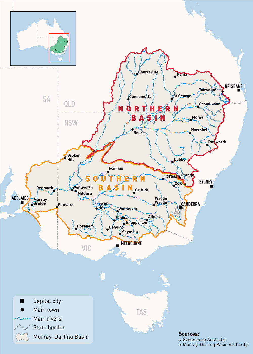
The Murray–Darling basin is the large geographical area in the interior of southeastern Australia. Its name comes from its two major rivers, the Murray River and the Darling River. It is one of the most significant agricultural areas in Australia. It spans most of the states of New South Wales, Victoria and the Australian Capital Territory and parts of the states of Queensland (lower third) and South Australia (southeastern corner). The basin has a land area of 1,061,469 km2 is flat, low-lying and far inland, and receives little direct rainfall. The many rivers it contains tend to be long and slow-flowing in areas that are very dry, hot and receive little rainfall. The Basin is one of the flattest and the 20th largest river catchments in the world.
Source: Murray Darling Basin Authority
The region is called a Basin because all of the streams, creeks and rivers run to a common point. There are 22 major catchments (or sub-Basins) within the Murray–Darling Basin. The waters of the northern catchments run to the Darling River and the waters of the southern catchment run to the River Murray.
The Basin is bounded to the east by the Great Dividing Range, including the Australia Alps, where snow lies for several months every winter. The north and west of the Basin is flat and semi-arid, taking in environments such as saltbush shrublands and mulga lands. Most rivers begin in the Great Dividing Range, flowing west and spreading across riverine plains of low elevation and very low gradients. Most of the major rivers flow into either the Darling or the Murray. There are some rivers, like the Gwydir, Paroo, Lachlan and Wimmera rivers that terminate in wetlands or marshes, and their water only reaches the Barwon, Darling or the Murray in the wettest of years, if at all.
The basin was once home to a large number of Aboriginal people whose traditional lifestyle and cultures have a long and strong connection. The rivers, floodplains and land are central to traditional cultural beliefs and practices, and provide water, rich and abundant sources of food, and shelter. There are almost 50 Aboriginal Nations whose traditional lands are within the Basin. Throughout the Basin, there are communities that maintain their traditional connections to the land and its rivers, or communities that are working to help reconnect their people to their heritage.
Source: Murray Darling Basin Authority
Our Northern Basin
Our northern region of the basin is generally referred to as the Northern Basin and covers an area of 726, 716 km2 contributing 68% of the total Murray Darling Basin land area. The region primarily comprises of a range of inland systems which include the Barwon–Darling, Macquarie–Castlereagh, Gwydir, Namoi, Border Rivers, Moonie, Condamine–Balonne, Warrego and Paroo river catchments. On many of these rivers systems major dams have been developed and their downstream rivers are now highly regulated. These dams help to reduce the risk of major flooding to downstream towns and inland cities and their regulated flows generally provide water deliveries for agricultural production. However, river regulation can act to change the natural flow regime that used to flow into our wetlands. Therefore in order to ensure the long term survival of our wet places, water flows that are critical for their natural wetland functioning must be maintained.

Source: GeoScience Australia/Murray Daring Basin Authority
Our region is home to at least 73 identified and important wetlands and their water systems. The mapping function includes the location of these important wetlands and its these wet places that form the network of sites where our waterbirds find food, habitats and breeding sites. A large proportion of our region has a semi-arid climate, being extended dry periods and shorter periods of flooding rains. Our rivers and wetlands systems have therefore adapted over time to these cycles and many of these places act as refuge areas for our waterbirds in the dry periods. When the rains come, our waterbirds then move from their refuge areas, flying widely across the region to other sites that have received water and are now in bloom.
It is critical that our important wetlands are protected from the main threats such has habitat loss, feral animals and loss of water flows. One way some of these area are being protected it through the Ramsar Convention on Wetlands.
The Ramsar Convention on Wetlands

The Whole Murray Darling Basin has over 30,000 wetlands, some of them listed internationally as Australia’s Ramsar wetlands for their importance to migratory birds that visit the site. To be healthy and promote life, the wetlands of the Basin need to be alternately wet and dry.
The Convention on Wetlands of International Importance holds the unique distinction of being the first modern treaty between nations aimed at conserving natural resources. The signing of the Convention on Wetlands took place in 1971 at the small Iranian town of Ramsar. Since then, the Convention on Wetlands has been known as the Ramsar Convention. The Ramsar Convention's broad aims are to halt the worldwide loss of wetlands and to conserve, through wise use and management, those that remain. This requires international cooperation, policy making, capacity building and technology transfer.
What are Ramsar wetlands?
Under the Ramsar Convention, a wide variety of natural and human-made habitat types ranging from rivers to coral reefs can be classified as wetlands. Wetlands include swamps, marshes, billabongs, lakes, salt marshes, mudflats, mangroves, coral reefs, fens, peat bogs, or bodies of water - whether natural or artificial, permanent or temporary. Water within these areas can be static or flowing; fresh, brackish or saline; and can include inland rivers and coastal or marine water to a depth of six metres at low tide. There are even underground wetlands.
The Ramsar Convention encourages the designation of sites containing representative, rare or unique wetlands, or wetlands that are important for conserving biological diversity. Once designated, these sites are added to the Convention's List of Wetlands of International Importance and become known as Ramsar sites. In designating a wetland as a Ramsar site, countries agree to establish and oversee a management framework aimed at conserving the wetland and ensuring its wise use. Wise use under the Convention is broadly defined as maintaining the ecological character of a wetland. Wetlands can be included on the List of Wetlands of International Importance because of their ecological, botanical, zoological, limnological or hydrological importance.
Australia's Ramsar Wetlands
Australia was one of the first countries to sign the Ramsar Convention, and in 1974 designated the world's first Wetland of International Importance: Cobourg Peninsula in the Northern Territory. Australia currently has 65 Wetlands of International Importance listed under the Ramsar Convention, covering approximately 8.1 million hectares, an area greater than Scotland or Tasmania.
In our region of the Northern Basin, there are six Ramsar listed wetlands, these include: the Macquarie Marshes 19 850 km2 , Currawinya Lakes 151 300 km2 , Lake Pinaroo 800 km2 , Gwydir Wetlands: (Gingham and Lower Gwydir (Big Leather) Watercourses) 823 km2 , Narran Lake Nature Reserve 5 531 km2 and Paroo River Wetlands 138 304 km2. In total 316, 608 km2 protected wetlands areas of International Importance.
More information
http://www.environment.gov.au/water/wetlands/ramsar